Sharks Equipped With Sensors Could Help Predict Hurricane Intensity
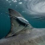


Scientists in the United States are testing whether sharks can help improve hurricane forecasts by carrying sensors that collect information about ocean conditions.
Researchers at the University of Delaware are tagging sharks with small devices that measure temperature, depth and electrical conductivity, which is closely linked to salinity.
The data could help scientists better understand conditions beneath the ocean surface and improve forecasts of hurricane intensity along the U.S. East Coast.
The research is focused on the Mid-Atlantic Bight, where scientists say important ocean data is still limited, particularly in nearshore and mid-shelf waters.
Ocean conditions can affect how strong a hurricane becomes. Researchers are especially interested in the heat stored in the ocean’s upper mixed layer, which provides energy to hurricanes.
How Sharks Collect The Data
The idea is to use sharks as mobile ocean-observing platforms.
Satellites and surface buoys already provide important information about the ocean, but they do not always give scientists enough information about what is happening below the surface.
Other systems, including underwater gliders, ship-based surveys and Argo floats, can collect subsurface data but can be expensive or difficult to use in some areas.
Sharks naturally move through different depths and parts of the ocean, giving researchers a possible way to collect data in places that are difficult to monitor regularly.
The CTD tags attached to the sharks record temperature, depth and conductivity. As the sharks dive and swim, the sensors collect measurements from different depths.
The information is transmitted to satellites when the shark’s dorsal fin reaches the surface. The tags can then send the collected data along with the shark’s GPS location to researchers.
Animal-borne sensors have already been used for years, including on elephant seals in polar regions where ocean observations are limited.
Carlisle said sharks offer another option because they are widely distributed and easier to access than many protected marine mammals.
Why Makos And Blue Sharks?
Researchers studied more than 20 years of satellite-tag data on shark movements in the Pacific and Atlantic oceans.
They examined 11 shark species to find which ones were most suitable for carrying the sensors.
Shortfin makos and blue sharks ranked highest because they surface often enough to give the tags opportunities to connect with satellites.
Shortfin makos were particularly promising. The sharks surface almost twice a day on average, allowing the sensors to collect information as they move through the water column.
Sharks, however, create a different challenge from seals. Seals need to surface to breathe, while sharks do not. Sharks can therefore remain underwater for long periods, reducing the chances for their tags to communicate with satellites.
Researchers had to design the equipment around the sharks’ natural behaviour.
First Tags Failed To Work Properly
The technology has already gone through several tests.
In 2023, researchers tested the first version of the system on two blue sharks. The tags did not consistently transmit data because of problems with their placement and the exposure of the antennas.
The team then redesigned the tag housing and mounting system to better fit different dorsal fins.
The new mount is rigid and shaped to fit the leading edge of the fin.
Researchers placed the redesigned tags on two shortfin makos in May 2025. One of the two sharks successfully transmitted CTD profiles and surface positions.
Carlisle said the project has involved repeated testing and changes as researchers work to make the system reliable.
Tagging Sharks Before Hurricane Season
The researchers want to collect data during the months leading up to and during hurricane season, when information about ocean conditions can be particularly useful for forecasting.
Shortfin makos and blue sharks arrive in the Mid-Atlantic in May after spending the winter farther offshore in the Atlantic.
Their movements differ during the summer.
Blue sharks move north toward cooler waters, while shortfin makos often remain in the Mid-Atlantic Bight through early fall before moving offshore.
Researchers want to tag sharks soon after they arrive and in different parts of the Mid-Atlantic to increase the area covered by the observations.
The tagging work takes place about 30 to 40 miles (50 to 65 km) offshore. Researchers travel on a research vessel, put baited lines into the water and usually wait two to three hours for a shark to take the bait, Wiernicki said.
Once a suitable shark is caught, the tag is attached to its dorsal fin. The procedure usually takes less than five minutes.
Carlisle compared the process to a pit crew working during a car race.
The work is carried out under institutional animal-care oversight. The tags are attached with materials designed to corrode and eventually fall off.
Researchers also check the health of each shark before releasing it. They want to avoid stressing or harming the animals because that could change their natural behaviour and affect the data.
Wiernicki said the real process is very different from the way sharks are shown in movies such as “Jaws” and the “Sharknado” series.
“It’s more like Bob from Accounting, clocking in with the day’s temperature profiles before he heads back out,” she said.
“We aren’t deploying sharks in and out of waterspouts, yet,” Wiernicki joked.
What Happens To The Data?
The research team plans to deploy at least two more CTD tags during the summer, focusing on shortfin makos and blue sharks.
The researchers will work with MARACOOS to add the collected profiles to OceansMap.
The data will then go through IOOS QARTOD quality-control procedures before being sent to the Global Telecommunication System and eventually to the Global Ocean Observing System.
The goal is to see whether sharks and other marine animals could eventually become part of a global system for collecting real-time ocean data.
It could also help scientists improve forecasts of hurricane intensity as storms approach the U.S. East Coast.
References: Reuters, Maracoos
Want to read more?
Check out the full article on the original site